
Storm Boris is causing extreme weather conditions in Central and Eastern Europe, resulting in record rainfall and 21 deaths so far. Meanwhile, Belgium is basking in the sun. Why is the country being spared from the torrential rain, and is it prepared for similar storms in the future?
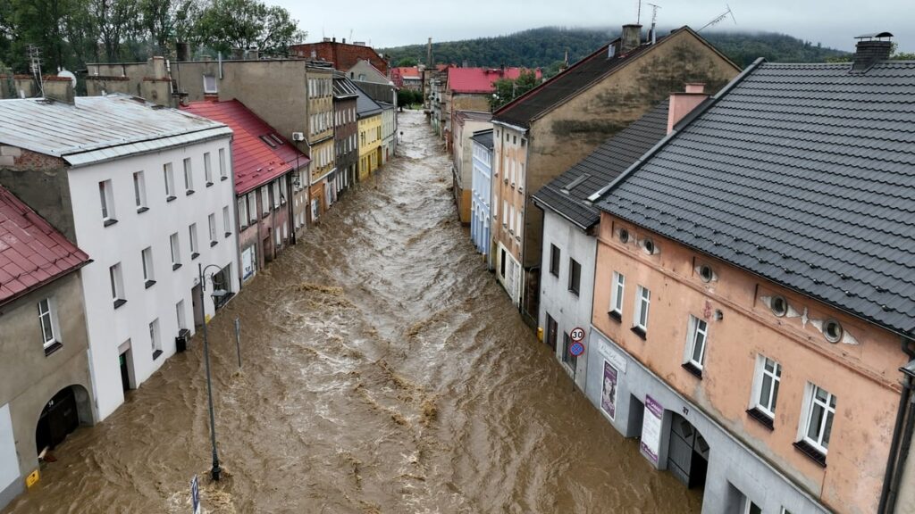
Since last week, large areas of Austria, Czechia, Hungary, Poland, Romania and Slovakia have been hit by Storm Boris, bringing around five times the average precipitation amount for September in a matter of days. The worst floods seen in the region in years have resulted in entire villages being submerged, thousands having to evacuate their homes, dams bursting and dozens of people being reported dead and missing.
"It is reasonable to refer to this type of extreme weather as a freak event," VUB climate scientist Wim Thiery told The Brussels Times. "Over 400 mm of rain fell in just 48 hours, in some places this figure was as high as 500 mm, and the previous record was broken by more than 100 mm. So, Storm Boris is really pulverising records."
What is causing this heavy rainfall?
Two "main ingredients" are contributing to this superstorm. Firstly, the intense "depression" is created by cold air from Northern Europe, colliding with the warm air extracted from the Mediterranean as well as the Black Sea, where temperatures are around 3°C to 5°C warmer than normal, bringing heavy humidity.
"This water evaporates and travels through the air currents to Central and Eastern Europe." When it encounters mountain ranges, such as in Austria, at the foothills of the Alps, the air starts rising and condensing, forming clouds with intensified rainfall.
As feared, Storm Boris is wreaking havoc across parts of Central Europe with major flooding becoming widespread throughout the region. Here’s a 50-hour visible satellite and radar loop courtesy of @zoom_earth pic.twitter.com/F9KRA2SKeO
— Nahel Belgherze (@WxNB_) September 15, 2024
Secondly, the blocked weather system formed by a winding jet stream means the low-pressure area (Storm Boris) is stuck between two high-pressure areas. This is why heavy rain continues to fall over one area. "It is very unique because high- and low-pressure areas normally shift from west to east," Thiery noted. "But because of that winding jet stream, the low-pressure zone is jammed."
Belgium is on the "right" side of the blockage, in a high-pressure zone, which explains the late summery weather the country will experience in the coming days. "We will see the sun shining during the day, but also experience cold nights."
Repeat of 2021 'water bomb'?
The images of Storm Boris wreaking havoc across several countries are reminiscent of the so-called "water bomb" that hit Belgium and neighbouring countries in July 2021, killing around 200 people.
Thiery says the comparison is apt: this storm also saw a low-pressure area being caught in between two high-pressure areas, while a constant supply of moisture came from the Baltic Sea. "It's the same idea in a different place." However, Storm Boris has brought much more precipitation: more than twice as much rain fell over a staggeringly large area.
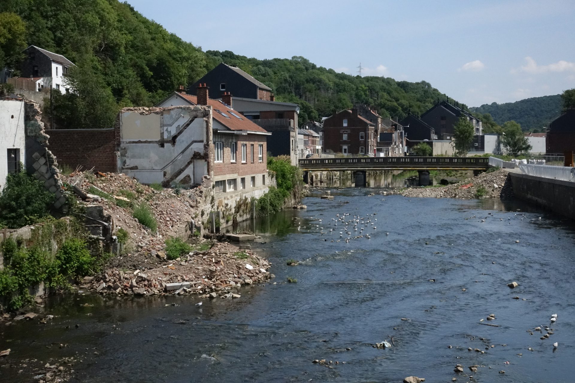
Damage caused by the July 2021 floods in Pepinster, Belgian Ardennes. Credit: Orlando Whitehead
When it comes to preparing for this "freak event", Thiery noted that, in terms of the weather forecasts, such storms can be sufficiently predicted. "Experts knew days in advance that such a large storm was advancing, and warnings were issued." In 2021, authorities were also alerted in advance in Belgium, but the warnings were not acted upon from a water management perspective.
"We did not pre-emptively open all our dams in advance, which the countries affected by Storm Boris have done to maximise their buffering capacity."
However, there are limits to how much a country can guard itself against this type of storm. "The reality is that these extremes are escalating to such an extent at the moment, that at some point we will reach the limits of what we can achieve with adaptation."
Climate change effect
Instead, he argued, the focus should be on mitigation. "The solution is to achieve net-zero emissions to stabilise global warming. While it is not possible to reverse the current level of warming, the sooner we address it, the more damage we are going to avoid."
Climatologists have already warned that climate change significantly increases the likelihood of intense precipitation. Storm Boris is also believed to have been exacerbated by climate change, according to a collective of climate scientists working together in the ClimaMeter initiative.
"There are several elements that point towards climate change having a strengthening effect on this storm," Thiery said. "We have already reached 1.3°C warming, and a warmer atmosphere can hold more moisture. This also means that when the air then effectively becomes saturated and clouds and rain form, there is more water present in the air, resulting in a stronger downpour when it does rain."
The marine heatwave increasing the temperature of the Black Sea by several degrees further adds to the supply of moisture. "Those marine heatwaves are particularly common at the end of a hot, dry summer, and they are a breeding ground for this type of storm, making the air unstable and creating more moisture."
Finally, climate change is adding to the "bendiness" of jet streams in the summer, meaning "atmospheric blocking" (lack of movement of high- and low-pressure zones) lead to persistent weather. "Regions in a high-pressure area will see longer periods of sunshine, warmth and drought, while in the low-pressure area, people will experience water bombs."